
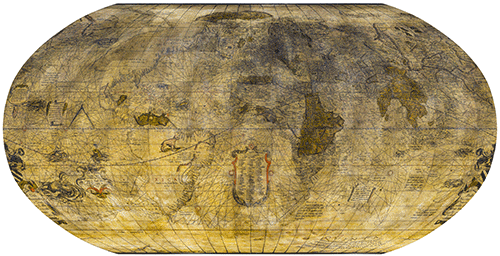
Edebat Gerardus Mercator Rupelmundanus cum privilegio Ces. Maiestatis ad an. sex Louanii an. 1541
Perrenot was an important figure in his time. He was chancellor in the court of Charles V and even a close adviser to the emperor. By 1541 he had held the position of guardian of the seals for nine years. On the globe, above Mercator’s dedication, are the Lord of Granvelle’s coat of arms and the words Sic visum superis (“Thus you will see the world from above”).

Illustriss[imo] D[omi]no Nicolao Perrenoto Domino a Granvella Sac[rae] Caesareae Ma[iesta]ti a consiliis primo dedicatu[m]

Si quorum voles locoru[m] distantia[m] cognoscere lector, circinu[m] eoru[m]de[m] distantiae adaptatu[m] in aequatore[m] transferto hic tibi q[ua]libet particula i[n]tercepta mille aria referet Hyp:18, Gal:20, Germ:15, Milia pas:60, Stadia:500

Europae aliquot insigniorum civitatum nomina, quae suis inferi locis angustia operis prohibuit
Here are the names of a few famous cities in Europe that lack of space prevented Mercator from indicating below their position.
1 Saltzburgum (Salisbury)
2 Bristou (Bristol)
3 Vestchester
4 Chester (Chester)
5 Jorc (York)
Scotiae (Scotland)
6 Edinburgum regia (Edinburgh)
7 Catnes
Hyberniae (Ireland)
1 Unflor
2 Solli
3 Dondal (Dundalk)
4 Dubelyn (Dublin)
5 Wacfort (Wateford)
6 Lamerich (Limerick)
7 Galuei (Galway)
1 Bermeo (Bermeo)
2 Soria olim Numantia (Soria formerly Numance)
3 Burgus (Burgos)
4 Compostella (Compostelle)
5 Marbella (Marbella)
6 Bera
7 Carthago nova (Cartagena)
8 Valentia (Valencia)
9 Tarracon (Tarragona)
10 Barsalona (Barcelona)
Galliae (Gaule)
1 Monspessulanus (Montpellier)
2 Tullium (Toul)
3 Roari (Rouen)
4 Verodunum (Verdun)
5 Sedunum (Sion)
6 Basilea (Basel)
7 Colonia Agrippina (Cologne)
8 Gandanum (Ghent)
9 Amsterodamum (Amsterdam)
1 Marcheburgum olim Amasia
3 Francofordia (Frankfurt)
4 Augusta Vindelicorum (Augsburg)
6 Norenberga (Nuremberg)
7 Praga (Prague)
8 Erfordia (Erfurt)
9 Brunsuiga (Brunswick)
10 Hamburgum (Hambourg)
11 Copenhaga metropolis Daniae (Copenhagen capital of the Danes)
12 Arhusen (Aarhus)
13 Schlesibyc (Schelswig)
14 Lubecum (Lübeck)
15 Stetin (Szczecin)
16 Brandenburgum (Brandebourg)
1 Patavium (Padova)
2 Aquilegia (Aquila)
3 Florentia (Florence)
4 Perusium (Perugia)
5 Sessa
6 Policastro (Policastro Bussentino)
7 Brundusium (Brindisi)
8 Adria
Greciae (Greece)
1 Messena (Messina)
2 Corinthus (Corinth)
3 Athenae (Athens)
4 Ambracia nunc Narta (Ambracie now Nartë)
5 Thessalonica (Thessaloniki)
6 Philippipolis
7 Adrianopolis (Edirne)

Albion & Hybernia insulae communi nomine Britannicae vocantur
The islands of Albion and Hybernia, commonly referred to as the British Isles.

Mangi nobilissima provincia 9 habet in se regna & 1200 civitates, evicta est a Tartaroru[m] Imp[eratore] Cublai anno 1268. Inter Mangi aute[m] et Zipangri insulam 7448 numeratas ait a nautis insulas M. Paul. Venetus lib. 3. cap. 8.

Insulas hic uspiam esse testatur M. Paul. Venetus in quibus certo anni tempore ruc avis apparet tam vastae magnitudinis ut elephantem in sublime attollat
Paulus Venetus states that there are islands somewhere in this area. At certain times of the year one can observe the rokh, a bird so large that by accounts it can lift an elephant into the air.


There seem to be a number of complementary reasons behind illustrations of sea monsters or other exotic creatures in the field of cartography. For mapmakers the idea was:
- to liven up the image of the world with decorative features,
- to fill empty spaces with information,
- to draw attention to the vitality of the oceans and the variety of creatures living in them,
- to suggest that the oceans and uncharted lands could be sources of danger,
- to serve as the graphic memory of literature on the subject,
- to provide points of reference in a geography of the marvellous,
- to draw attention to the artistic talent of the cartographer, who could then sell his work at a higher price, depending on the quality and quantity of the illustrations.
Sea and land creatures
For historians, three representations of sea monsters are predominant in Renaissance cartography: Olaus Magnus‘s Carta Marina (1539); the Monstra Marina & Terrestria map (1544) by Sebastian Münster, partly inspired by Olaus Magnus; and the Islandia map by Abraham Ortelius, published in Theatrum Orbis Terrarum (1586) and inspired by the two previous works.
Gerardus Mercator was particularly influenced by Magnus’ Carta marina, which contained the largest, most varied and most comprehensive collection of sea monsters of the day.

Mercator’s terrestrial globe is illustrated with eleven sea monsters, seven of which were taken from Magnus’s Carta marina and two others from Gonzalo Fernandez de Oviedo‘s Historia general de las Indias (1535), a book that represented the very first images of animals in America. Mercator no doubt used both Magnus and Oviedo to demonstrate his ability to combine the most recent sources in a nutshell. In addition to the sea monsters he included one terrestrial animal.


The monsters in cartography provides a detailed roundup of Mercator’s sources and inspirations for the twelve sea monsters and opossum.
Find out more
- Monsters in cartography : a detailed roundup of Mercator’s sources and inspirations for the twelve sea monsters and opossum.
- Carta marina : by Olaus Magnus, digitised document, World Digital Library: National Library of Sweden.
- Cosmographey, das ist Beschreibung aller Länder : by Sebastian Münster, German edition 1598, digitised document, Gallica: National Library of France.
- Theatrum Orbis Terrarum : by Abraham Ortelius, digitised document of the 1570 edition, Library of Congress.
- Duzer, van C. (2014) Sea Monsters on Medieval and Renaissance Maps, London : The British Library.
- Nigg, Joseph (2013) Sea Monsters. A voyage around the world’s most beguiling Map, Chicago & London : The University of Chicago Press.


In his treatise De mundi creatione ac fabrica Liber, Mercator strove to prove the existence of a fifth continent that he called Quinta. For him and other scholars of the time, this landmass was necessary to counterbalance the weight of Europe, Africa and Asia, mainly situated in the northern hemisphere. For the world to be in kilter, Quinta had to be as large as all its antagonists put together. Mercator thus represented the fifth continent as stretching around the entire globe with a very uneven coastline.
With no maritime discoveries to guide him, we can see that Mercator committed the same error as other geographers of his period by believing in the existence of a wondrous southern land as vast as the Old World. This was represented with a host of variations by 16th-century cartographers, in all shapes and sizes depending on their beliefs and on interpretations of the voyages of Magellan, Marco Polo and others.
We can hardly criticise Mercator for depicting in 1541 imaginary lands which, according to Jocodus Hondius, were still totally unknown in 1617.


Find out more
- Collection of maps dating from 1599 to 1630 : by Jocodus Hondius, digitised documents, University of Amsterdam Library


Mercator’s America is a largely unexplored continent whose outline are still uncertain. The western shorelines of North America and the southern shores of South America appear uncharted, with no place names, contrasting sharply with the rich toponymy of the eastern coastlines, the Caribbean and Central America. These were already well documented by the great contemporary discoveries.
South America is shown wider than its actual east-west dimension and too short north-south. To fill part of the vacant space in the interior, Mercator drew an opossum, an animal that symbolised the tropics. Yet this image, inspired by other maps, is neither properly proportioned nor very realistic: here the opossum’s pouch sits at shoulder level, not at its hips.
While the shape and position of the Americas are incorrect, one wonders how Mercator was able to convey such a complete and fair image of continents that were still largely unexplored. His representation is innovative and almost faithful to reality compared with the misshapen attempt by a contemporary cosmographer, Sebastian Munster. Even maps published a century later in Holland would not be as precise.
Despite the Spanish and Portuguese courts’ censorship of details about their maritime expeditions, and despite the absence of newspapers, Mercator managed to glean an incredible amount of information. It was almost as if, map in hand, he had followed the mariners on their voyages of discovery and published the findings at the same time they were made known to the monarchs who had commissioned the expeditions.


By Mercator’s day, explorers had already been seeking a passage over North America to the Pacific Ocean for some time. On the face of it the German-Flemish cartographer changed his mind about its existence sometime during his career. On his 1541 globe, the landmass continues with no break between North America and the Arctic. But on the map published the year after he died, in 1595, he drew a strait separating California and the North Pole.
While Mercator did not give the North-West Passage a name, the Spaniards called it the “Strait of Anian”. Several expeditions were already mounted to search for it throughout the 1700s. But despite the many attempts to find it over the centuries, the route would not be mapped out at last until 1906 by Roald Amundsen.

Christened Tierra del Fuego, the region seemed to spell bad luck for succeeding expeditions that would venture through it. Tierra del Fuego long remained an enigma and the cartographer Johann Schöner believed that another huge landmass lay south of the strait. The myth of this southern continent, conceived by the Greeks in Antiquity and handed down by medieval scholars, continued to be represented in the 16th century, for example on Oronce Fine‘s 1531 world map and on Mercator’s 1541 terrestrial globe.
It would not be until the 1580s that an expedition disembarked on the desolate shores of Tierra del Fuego.

General view of the Caribbean


Find out more
- Cosmographiae universalis : by Sebastian Munster, digitised document, National Library of Portugal
- Nova et integra universi orbis descriptio : by Oronce Fine, digitised document, National Library of France: Gallica

Paulus Venetus (1369–1429)
The difficulty of reconciling Ptolemy’s view of South Asia and recent discoveries there was likely the main reason that prompted Mercator to produce his own terrestrial globe. He strove to adapt the representation of the Earth inherited from the ancient geographers to the findings of the 16th century.
Even so, there are still numerous errors in Mercator’s portrayal of the Asian continent: it stretches too far to the west. Other inaccuracies stem from a misinterpretation of Marco Polo’s travelogue.
In various insets illustrating Asia, Mercator refers to Paulus Venetus, or Paul of Venice, an Italian philosopher whom he also used as a source.
 People travelling the Mongolian routes in the Middle Ages crossed a region whose inhabitants were called Khitans or Kitai. This gave rise to the name Cathay, which at the time designated a territory corresponding roughly to China.
Twenty years before Marco Polo, Guillaume de Rubrouck, a Franciscan monk originally from Flanders, provided the first-ever description of Chinese, Uyghurs, Tanguts, North Tibetans and Koreans.
Other clergymen sojourned in Armenia, Persia, Mongolian China and Cathay in the 12th and 13th centuries, but it was mainly thanks to the writings of Marco Polo Cathay would become a legendary land.

The island of Ceylon was initially known by the enchanting name Trapobana. This word evoked the island’s shape (tamraparni in Sanskrit) as well as the colour of its earth (tambapanni in Sinhalese).
For Greek sailors Trapobana was the Antipodes, i.e. the land at the end of the Earth. It was reached by the fleet of Alexander the Great in the 6th century BC. Much later a number of rich Venetians would visit the island and the neighbouring areas.
Trapobana was not only fabled for its riches but also because, since the voyage of the merchant Suleiman in the 6th century, it was said that Adam and Eve had found refuge there. Many Christian authors would therefore stubbornly imagine Trapobana as Heaven on Earth.
Although Polo never set foot there, Zipangri frequently filled his dreams and fantasies. It thus came to represent all that is most fabulous about the Orient, stirring the fancy of travellers, merchants and cartographers across the West. It was in an attempt to reach these regions that Christopher Columbus sailed west, in 1492, and would only admit after his third voyage that he never arrived there.

The Land of the Rising Sun was finally reached by the Portuguese in 1543. However, the archipelago’s composition and coastlines remained obscure until the late 16th century. The first more or less accurate map of Japan would not appear until the dawn of the next century.


According to historians the main source for Mercator’s representation of Africa was Martin Waldseemüller’s Carta marina navigatoria (1516), particularly as regards the network of waterways and the northern interior. This work had been practically ignored by Gemma Frisius.
The outlines of the African continent on Mercator’s globe are rich in detail and toponyms, representing major changes compared with Frisius’ globe. But even so little was known about the interior for a long time. Only the coasts were well explored and dotted with trading posts. The circumnavigation of Africa by Portuguese sailors in the late 15th century would roll back the frontiers of the oecumene to some extent, but the hinterland would remain unexplored and unknown. It would not be until the end of the 18th century that expeditions ventured further inland.
Although the broad outline of Arica seems about right at first glance, overlaying the current projection points up major differences on a general scale.
Martin Behaim, Mercator’s forerunner in Germany, put the sources of the Nile in the vast stretches of Ethiopia. Mercator himself preferred to situate them south of the equator, projecting them as being fed by two subequatorial lakes surrounded by a network of mountains. This followed Ptolemy’s conception.


Mercator took great care to represent every segment of the Nile’s course, from its delta divided into seven mouths up to the two lakes where it rises. In order these segments are called Alcair, Apollinis, Syene, Berethis, Sacala and Zoquila. On the branch that flows out of the western lake we find Neli, Zodiata, Ithia, Gorala, Gaida, Chaga and Meraga. On the branch flowing from the eastern lake are Bersera, Haba, Singa, Caigra, Baricia, Ropoga, Uque, Heicer, Buatili, Sesila, Losa, Caba, Girat and Bara. Several of these names are taken from Ptolemy.
In 1488 Bartolomeu Dias came to a headland swept by ferocious winds. He had reached the most southerly point of the African continent, which he named Cape of Storms. It was rechristened Cape of Good Hope to herald the proximity of the Indies. In 1497 Vasco de Gama would sail all the way around Africa to India.


Below the southern tip of Africa, beyond the Cape of Good Hope, Mercator called a part of the Antarctic continent Psitacorum regio, “Land of the Parrots”.


Find out more
- Carta marina navigatoria Portugallen : by Martin Waldseemüller, digitised document, Luso-Brasileira Digital Library.


Mercator corrected a major error in Ptolemy’s conception of the longitudinal reach of Europe. He contended that the continent lay much farther east and thereby also rectified the latitude of the Canary Islands. This resulted in a reduction of the Mediterranean’s overextension by Ptolemy. Even though its proportions were still far off the mark, this correction nevertheless represented a major stride forward, especially for navigation.
Europae aliquot insigniorum civitatum nomina, quae suis inferi locis angustia operis prohibuit
Europae aliquot insigniorum civitatum nomina, quae suis inferi locis angustia operis prohibuit
Here are the names of a few famous cities in Europe that lack of space prevented Mercator from indicating below their position.
1 Saltzburgum (Salisbury)
2 Bristou (Bristol)
3 Vestchester
4 Chester (Chester)
5 Jorc (York)
Scotiae (Scotland)
6 Edinburgum regia (Edinburgh)
7 Catnes
Hyberniae (Ireland)
1 Unflor
2 Solli
3 Dondal (Dundalk)
4 Dubelyn (Dublin)
5 Wacfort (Wateford)
6 Lamerich (Limerick)
7 Galuei (Galway)
1 Bermeo (Bermeo)
2 Soria olim Numantia (Soria formerly Numance)
3 Burgus (Burgos)
4 Compostella (Compostella)
5 Marbella (Marbella)
6 Bera
7 Carthago nova (Cartagena)
8 Valentia (Valencia)
9 Tarracon (Tarragona)
10 Barsalona (Barcelona)
Galliae (Gaule)
1 Monspessulanus (Montpellier)
2 Tullium (Toul)
3 Roari (Rouen)
4 Verodunum (Verdun)
5 Sedunum (Sion)
6 Basilea (Basel)
7 Colonia Agrippina (Cologne)
8 Gandanum (Ghent)
9 Amsterodamum (Amsterdam)
1 Marcheburgum olim Amasia
3 Francofordia (Frankfurt)
4 Augusta Vindelicorum (Augsburg)
6 Norenberga (Nuremberg)
7 Praga (Prague)
8 Erfordia (Erfurt)
9 Brunsuiga (Brunswick)
10 Hamburgum (Hamburg)
11 Copenhaga metropolis Daniae (Copenhagen capital of the Danes)
12 Arhusen (Aarhus)
13 Schlesibyc (Schelswig)
14 Lubecum (Lübeck)
15 Stetin (Szczecin)
16 Brandenburgum (Brandenburg)
1 Patavium (Padova)
2 Aquilegia (Aquila)
3 Florentia (Florence)
4 Perusium (Perugia)
5 Sessa
6 Policastro (Policastro Bussentino)
7 Brundusium (Brindisi)
8 Adria
Greciae (Greece)
1 Messena (Messina)
2 Corinthus (Corinth)
3 Athenae (Athns)
4 Ambracia nunc Narta (Ambracie now Nartë)
5 Thessalonica (Thessaloniki)
6 Philippipolis
7 Adrianopolis (Edirne)


Mercator made sweeping improvements to the cartography of Northern Europe by drawing on the Carta Marina by the Swedish writer Olaus Magnus. Finland extends all the way up to the White Sea, however, no doubt in reference to the map of Scandinavia drawn by Jakob Ziegler. But Mercator mainly strove to correct the area between Greenland and the Ural Mountains including :
- Ukraine and southern Russia (Scythia),
- Lithuania and Moscow more or less (Sarmatia),
- Scandinavia (Scandia),
- Scotland (Scotia),
- Iceland (Islandia),
- the islands in the Sea of Norway (Deucaledonius maris)


On Mercator’s globe the regions of the North Pole include only Island insula olim Thyle, Grimse insula, Groenlandia, its neighbour Margaster and a few smaller islands situated along the southern coast of Groenlandia. Greenland is part of the continent of North America. Its uninhabited portion extends beyond the pole and measures nearly 30 degrees at its widest point.
The rest of the Arctic area is shown as seas, of which Mercator distinguishes Tabin Mare and Mare Cronium vel Amalchium hoc est congelatum.
Greenland, with its two settlements Alba and Solotobab inhabited by the Screlingers, its mountain chains and its Diver and Thor Rivers, occupies almost half the circumpolar regions.
The northern tips of Norway, with its province Scricfinnia, of Russia, with Juhra regio ex qua Hungaros prodiisse volunt, and of Asia, with the Tabin headland and the Belgian desertum, extend up to the latitude of the inhabited part of Groenlandia. They could therefore also be considered as forming part of the northern regions on Mercator’s globe.
We should not be surprised by the various representations of the circumpolar areas. In 1572 Abraham Ortelius (1527-1598) noted that nothing was yet known about the regions near the North Pole, or whether they were made of land or ocean, and that a host of tales were told about these remote climes. On his planisphere in 1569 Mercator would depict the arctic regions quite differently.
Find out more
- Carta marina : par Olaus Magnus, document numérisé, Bibliothèque numérique mondiale : Bibliothèque nationale de Suède.
- Theatrum Orbis Terrarum : par Abraham Ortelius, document numérisé, Library of Congress.
Si quorum voles locoru[m] distantia[m] cognoscere lector, circinu[m] eoru[m]de[m] distantiae adaptatu[m] in aequatore[m] transferto hic tibi q[ua]libet particula i[n]tercepta mille aria referet Hyp:18, Gal:20, Germ:15, Milia pas:60, Stadia:500.
If you, reader, wish to know the distance to certain places, measure it as adjusted by the compass placed on the equator; the distance will be 18 Spanish miles, 20 French miles, 15 German miles, 60,000 podes, 500 stadia.
This comparison of measurements suggests that it was Mercator himself who calculated the conversions, though he did not mention this anywhere. Nor did he explain the method he used to arrive at these results.
In a period marked by diverging views regarding the actual size of the Earth, Mercator estimated its circumference to be 21,600,000 podes or 180,000 stadia. The globe’s scale is roughly 1:30,000,000.
On his terrestrial globe, Mercator divided the known world into five parts: Europe, Africa, Asia, America et la Quinta, a recently discovered southern continent. New Guinea does not appear. Nor do Australia and New Zealand, which would not be discovered until the wave of expeditions to the South Seas in the 18th century.

Find out more
- Horst, T. (2011) Le monde en cartes : Gérard Mercator (1512-1594) et le premier atlas du monde, Gütersloh/Munich : Faksimile Verlag et Bruxelles : Fonds Mercator.
- Krogt, P. van der (1993) Globi Neerlandici : the production of globes in the Low Countries, (trad. E. Daverman), Utrecht : HES Publ.
- Lanni, D. (2015) Atlas des contrées rêvées, Paris : Flammarion.
- Raemdonck, J. Van (1875) « Les sphères terrestre et céleste de Gérard Mercator », in : Annales du Cercle Archéologique du Pays de Waes, vol. 5, pp. 254-324.
Mercator was influenced by Ptolemy and Marco Polo but he did not bow to them. He knew how to use their writings while also rectifying and surpassing them, integrating the pragmatic knowledge gleaned from recent discoveries into his work.
Claudius Ptolemy


Almageste influenced Mercator’s representation of the outline of the Mediterranean basin, the interior of Europe, the islands dotting the Gulf of Arabia, the sources of the Nile, the mountains of Africa, the waterways that empty into the Persian Gulf and the Caspian Sea, those that cross Asia, the Indus and Ganges Rivers on the Indian subcontinent and a few other rivers in China and Siberia.
Yet Mercator added considerable breadth and depth to Ptolemy’s legacy. He represented the recently discovered American continent, raised Africa from beneath the blank Southern Ocean all the way to the Cape of Good Hope and revealed new parts of Asia between Cape Comorin and the Malacca peninsula. Groenlandia, Islandia, Norvegia, Livonia and many other names of cities and kingdoms were also new, replacing the ones used by Ptolemy in his day.
Robinson projection of Mercator’s terrestrial globe with an overlay of Ptolemy’s map. @ UNIL
Mercator’s terrestrial globe shows most of the discoveries or geographical reconnaissance reported by contemporary mariners and great explorers. Obviously, these features did not appear in Ptolemy’s work. Mercator thus went a long way towards discrediting the Greek geographer, whose writings were gradually consigned to the dustbin. Mercator can be regarded as the agent of this change and as the founder of modern geography.
Marco Polo


In 1271 Marco Polo left Venice to explore the Orient. Accompanied by two other Venetian merchants, he crossed the high Anatolian plateaus, Iran, Upper Afghanistan, Pamir and Chinese Turkestan, finally arriving in Beijing. He remained in China for sixteen years, travelling extensively around the country. On his return journey he visited Indochina, Ceylon, the shorelines of India and other regions unexplored until then such as the Arabian coast, Ethiopia and the African seaboard down to Zanzibar. Polo’s 20-year odyssey was related from 1298 in The Description of the World, also called The Book of the Marvels of the World.
Mercator drew heavily on this compendium. His globe features a host of islands, kingdoms, provinces and places in the locations cited by Polo, sometimes even with the same spelling.


Find out more
- Ptolemy’s contribution : it could be said that the Greek scientist Ptolemy was at once the last great cartographer and astronomer in Antiquity and the first of the Western world.